


Streamline Statewide Alert Workflow
Save time and get alerts out faster
When every second counts, manual alerting workflows slow response and increase risk. Phone calls, emails, and verbal descriptions of alert areas create delays, geographic confusion, and inconsistent public messaging. With Genasys Protect, modernize statewide emergency alert processes with a unified, map‑based platform that enables faster approvals, precise targeting, and clear communication, so agencies can act decisively when it matters most.
Work faster and get the tools to make your job easier!
Make statewide alerts faster with less effort in coordination with county agencies.
Coordinate Easier
Local agencies submit alert requests through a secure portal while state agencies review and approve them in one shared system that eliminates manual handoffs and communication gaps.
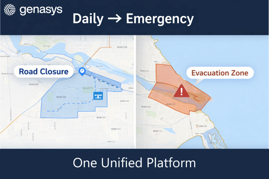
Map-Based Precision
Alert zones are defined visually using existing GIS data, reducing confusion caused by text‑based or verbal boundary descriptions.
Notify Faster
Standardized, map‑based workflows reduce approval timelines from hours to minutes, accelerating public notification during critical incidents.
Public Clarity
Alerts include interactive maps and consistent messaging so the public clearly understands where an incident is occurring and what actions to take
Modernize slow, time-consuming legacy processes
The Current Way:
With Genasys Protect:

Local agencies call or email the state to request alerts, often repeating information multiple times.

Local agencies submit standardized alert requests through a secure, map‑based portal with all required details included.

Alert boundaries are described verbally or in text, leading to misunderstandings and over‑alerting.

Agencies draw precise alert zones directly on a shared map that both local and state teams see instantly.

State reviewers lack geographic context, slowing approvals and increasing risk.

State agencies review alert details on a centralized dashboard with full geographic visibility and approve with a single click.

Alerts are rushed out with inconsistent messaging and limited context.

Alerts are standardized and include interactive maps, ensuring clarity across all channels.

The public receives broad, and sometimes vague, alerts with large, affected areas, leading to alert fatigue.

Citizens receive actionable alerts with clear map‑based views that show exactly where an incident is.
Ready for Genasys Protect to simplify statewide alert process?
Even more statewide solutions:
Evertel’s Real Time Crime Center Modernization
When you depend on speed, precision, and coordination, what collaboration solutions are up to the task? Email is slow and segmented. Non-compliant apps like Signal, WhatsApp, GroupMe, and Telegram come with significant risks and inefficiencies.
Genasys Evertel is the secure communication and collaboration platform tailored for public safety agencies. Enhance RTCCs with real-time intelligence sharing and rapid coordination, and see why Evertel is the Mobile Regionalization Platform.